안녕하세요? 이번 글은 Earth Engine Data Catalog에서 제공하는 global Human Modification(gHM) 데이터셋을 간략히 소개해 보겠습니다.
Earth Engine Data Catalog
Earth Engine Data Catalog는 Google Earth Engine에서 사용 가능한 데이터셋 및 이미지 컬렉션에 대한 정보를 포함하는 온라인 데이터 리포지토리입니다. 데이터셋(Dataset)은 Google Earth Engine에서 관리되는 정형 데이터를, 이미지 컬렉션(Image Collection)은 동일한 데이터셋의 여러 시간 스탬프들을 묶어서 처리하기 쉽게 만든 개념입니다.

CSP gHM: Global Human Modification
CSP gHM: Global Human Modification | Earth Engine Data Catalog | Google for Developers
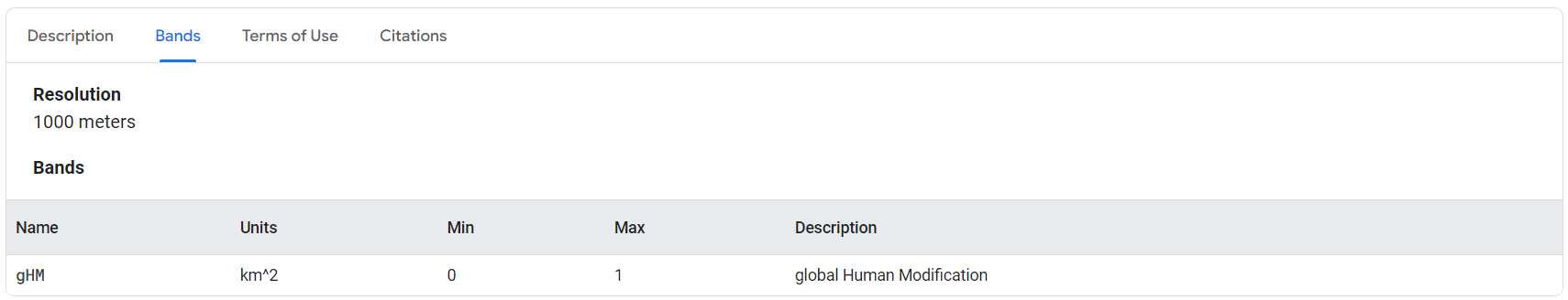
The global Human Modification dataset (gHM) provides a cumulative measure of human modification of terrestrial lands globally at 1 square-kilometer resolution. The gHM values range from 0.0-1.0 and are calculated by estimating the proportion of a given loc
developers.google.com
global Human Modification(gHM) 데이터셋은 전세계적으로 인간이 지구상의 육지를 변경한 누적 측정값을 1㎢ 해상도로 제공합니다. gHM 값의 범위는 0.0-1.0이고 주어진 위치(픽셀)의 변경 비율을 추정하며, 주어진 유형의 인간 변경 또는 "스트레스 요인"과 관련된 추정 강도로 계산됩니다. 2016년에 13개의 개별 데이터셋을 사용하여 5가지 주요 인간 활동으로 인한 스트레스 요인이 매핑되었습니다.
- 인간 정착지 (인구 밀도, 시가지)
- 농업 (경작지, 가축)
- 교통 (주요/소/미개량 도로; 철도)
- 광업 및 에너지 생산
- 전기 인프라 (전선, 야간 조명)
CSP(Conservation Science Partners, 보전 과학 파트너스)는 다양한 보전 프로젝트 이해관계자들의 분석 및 연구 수요를 충족시키기 위해 설립된 비영리 단체입니다.
gHM 데이터셋 검색 및 다운로드
geemap과 ee 모듈을 가져오고, Earth Engine에 인증하고 초기화하는 작업을 수행합니다. ee.Authenticate() 함수는 Earth Engine과 연결된 Google 계정으로 인증하고 인증 토큰을 얻는 역할을 합니다. 한 번 인증이 완료되면, 그 이후에는 인증 코드를 다시 입력할 필요 없이 해당 인증 토큰을 사용하여 Earth Engine과 통신할 수 있습니다.
import geemap
import ee

# Earth Engine 인증
ee.Authenticate()

# Earth Engine 초기화
ee.Initialize()
Earth Engine Data Catalog에서 FAO GAUL (Global Administrative Unit Layers) 2015 국가 경계를 불러와, 대한민국을 필터링하고 해당 경계를 시각화합니다. FeatureCollection은 점, 선, 폴리곤과 같은 공간 데이터를 나타내는데 사용됩니다.
FAO GAUL: Global Administrative Unit Layers 2015, Country Boundaries | Earth Engine Data Catalog | Google for Developers
The Global Administrative Unit Layers (GAUL) compiles and disseminates the best available information on administrative units for all the countries in the world, providing a contribution to the standardization of the spatial dataset representing administra
developers.google.com
# FAO GAUL: Global Administrative Unit Layers 2015, Country Boundaries
countries = ee.FeatureCollection("FAO/GAUL/2015/level0")

# 'ADM0_NAME' 필드를 기준으로 '대한민국' 필터링
kr = countries.filter(ee.Filter.eq('ADM0_NAME', 'Republic of Korea'))

# 지도 생성
Map = geemap.Map()

# 지도에 경계 표시
Map.centerObject(kr, 7) # 경계 중심으로 지도 확대
Map.addLayer(kr, {}, "Republic of Korea")

# 지도 출력
Map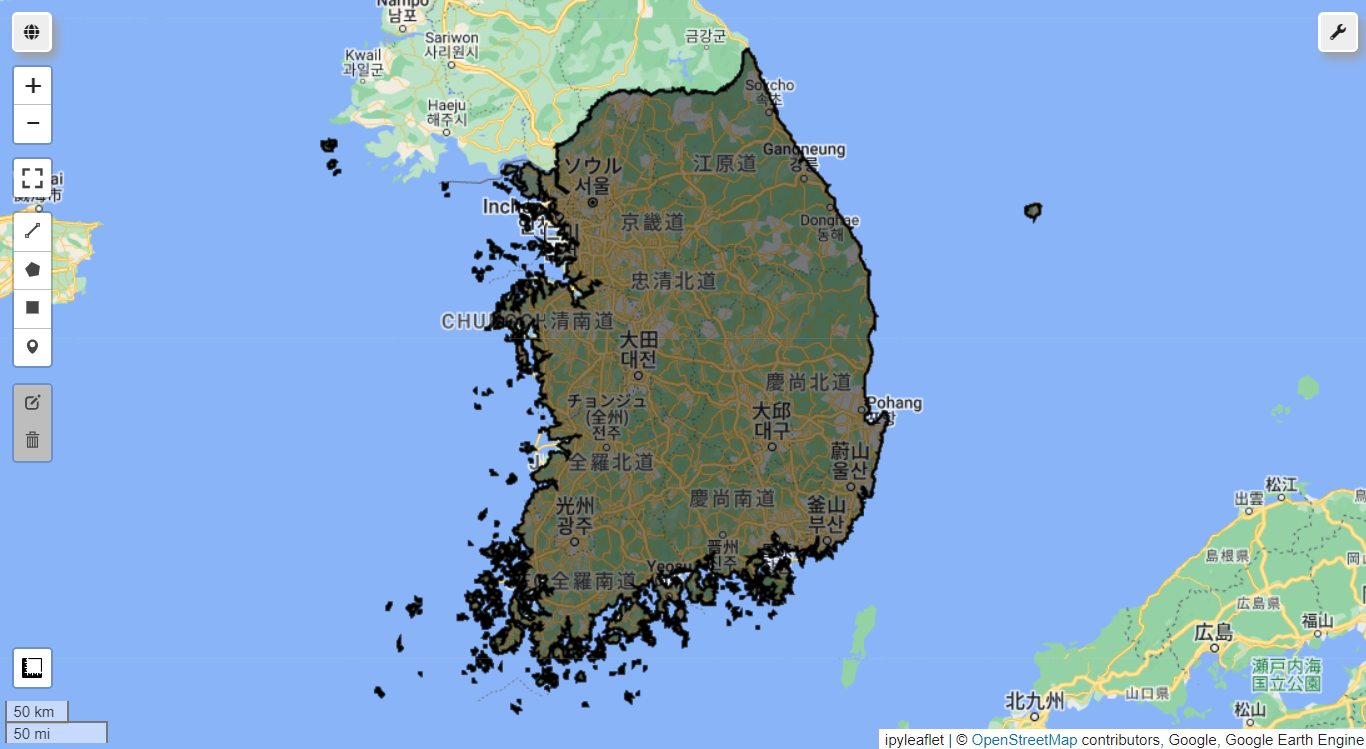
gHM을 시각화해 봅니다.
# CSP gHM: Global Human Modification
gHM = ee.ImageCollection('CSP/HM/GlobalHumanModification').median()

visParams = {
    'min': 0.0,
    'max': 1.0,
    'palette': ['0c0c0c', '071aff', 'ff0000', 'ffbd03', 'fbff05', 'fffdfd']}

# 지도 생성
Map = geemap.Map()

Map.centerObject(kr, 7) # 경계 중심으로 지도 확대
Map.addLayer(gHM, visParams, 'gHM (global Human Modification)')
Map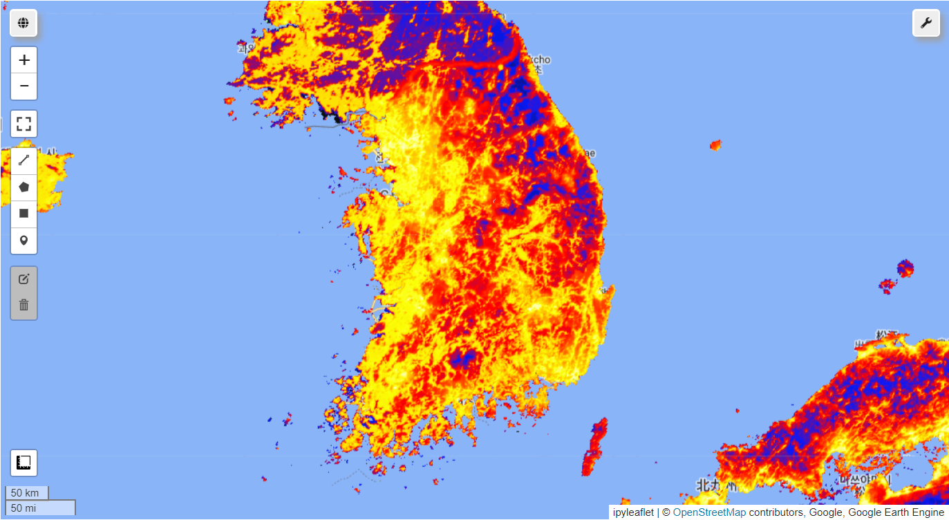
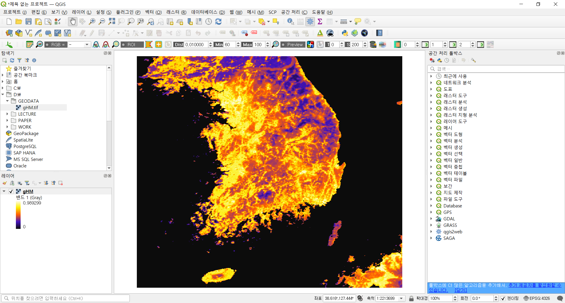
gHM을 대한민국 영역으로 잘라내어 GeoTIFF 파일로 저장합니다.
# 대한민국 영역으로 잘라내기
gHM_kr = gHM.clipToCollection(kr)

# 데이터를 GeoTIFF 형식으로 저장
output_file = 'D:/GEODATA/gHM.tif'
geemap.ee_export_image(gHM_kr, filename=output_file, region=kr.geometry(), scale=1000)
이제 해당 데이터는 QGIS에서도 다룰 수 있습니다. 여기까지 Earth Engine Data Catalog에서 제공하는 global Human Modification(gHM) 데이터셋을 조회하고 다운로드 받는 과정을 정리해 봤습니다.