
안녕하세요? 이번 글은 Earth Engine Data Catalog에서 제공하는 OpenLandMap Precipitation Monthly(월별 강수량) 데이터셋을 간략히 소개해 보겠습니다.
Earth Engine Data Catalog
Earth Engine Data Catalog는 Google Earth Engine에서 사용 가능한 데이터셋 및 이미지 컬렉션에 대한 정보를 포함하는 온라인 데이터 리포지토리입니다. 데이터셋(Dataset)은 Google Earth Engine에서 관리되는 정형 데이터를, 이미지 컬렉션(Image Collection)은 동일한 데이터셋의 여러 시간 스탬프들을 묶어서 처리하기 쉽게 만든 개념입니다.

OpenLandMap Precipitation Monthly
OpenLandMap Precipitation Monthly | Earth Engine Data Catalog | Google for Developers
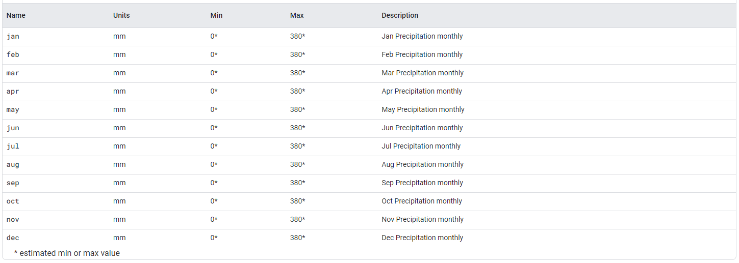
Monthly precipitation in mm at 1 km resolution based on SM2RAIN-ASCAT 2007-2018, IMERG, CHELSA Climate, and WorldClim. Downscaled to 1 km resolution using gdalwarp (cubic splines) and an average between WorldClim, CHELSA Climate, and IMERG monthly product
developers.google.com
OpenLandMap Precipitation Monthly 데이터셋은 SM2RAIN-ASCAT 2007-2018, IMERG, CHELSA Climate 및 WorldClim을 기반으로 한 1km 해상도의 월별 강수량(mm) 정보를 제공합니다. 이 데이터셋은 IMERG, CHELSA Climate 및 WorldClim 월별 제품 간의 평균을 gdalwarp(큐빅 스플라인)를 사용하여 1km 해상도로 축소했습니다. SM2RAIN-ASCAT 데이터는 더 정확하다고 가정하므로 3배 더 높은 가중치가 부여되며, 산출물에 남극 대륙은 포함되지 않습니다.

OpenLandMap Precipitation Monthly 데이터셋 검색 및 다운로드
geemap과 ee 모듈을 가져오고, Earth Engine에 인증하고 초기화하는 작업을 수행합니다. ee.Authenticate() 함수는 Earth Engine과 연결된 Google 계정으로 인증하고 인증 토큰을 얻는 역할을 합니다. 한 번 인증이 완료되면, 그 이후에는 인증 코드를 다시 입력할 필요 없이 해당 인증 토큰을 사용하여 Earth Engine과 통신할 수 있습니다.
import ee
import geemap
import geemap.colormaps as cm

# Earth Engine 인증
# ee.Authenticate()

# Earth Engine 초기화
ee.Initialize()
Earth Engine Data Catalog에서 FAO GAUL (Global Administrative Unit Layers) 2015 국가 경계를 불러와, 대한민국을 필터링하고 해당 경계를 시각화합니다. FeatureCollection은 점, 선, 폴리곤과 같은 공간 데이터를 나타내는데 사용됩니다.
FAO GAUL: Global Administrative Unit Layers 2015, Country Boundaries | Earth Engine Data Catalog | Google for Developers
The Global Administrative Unit Layers (GAUL) compiles and disseminates the best available information on administrative units for all the countries in the world, providing a contribution to the standardization of the spatial dataset representing administra
developers.google.com


# FAO GAUL: Global Administrative Unit Layers 2015, Country Boundaries
countries = ee.FeatureCollection("FAO/GAUL/2015/level0")

# 'ADM0_NAME' 필드를 기준으로 '대한민국' 필터링
kr = countries.filter(ee.Filter.eq('ADM0_NAME', 'Republic of Korea'))

# 지도 생성
Map = geemap.Map(basemap='USGS.USImagery')

# 지도에 경계 표시
Map.centerObject(kr, 6) # 경계 중심으로 지도 확대
Map.addLayer(kr, {}, "Republic of Korea")

# 지도 출력
Map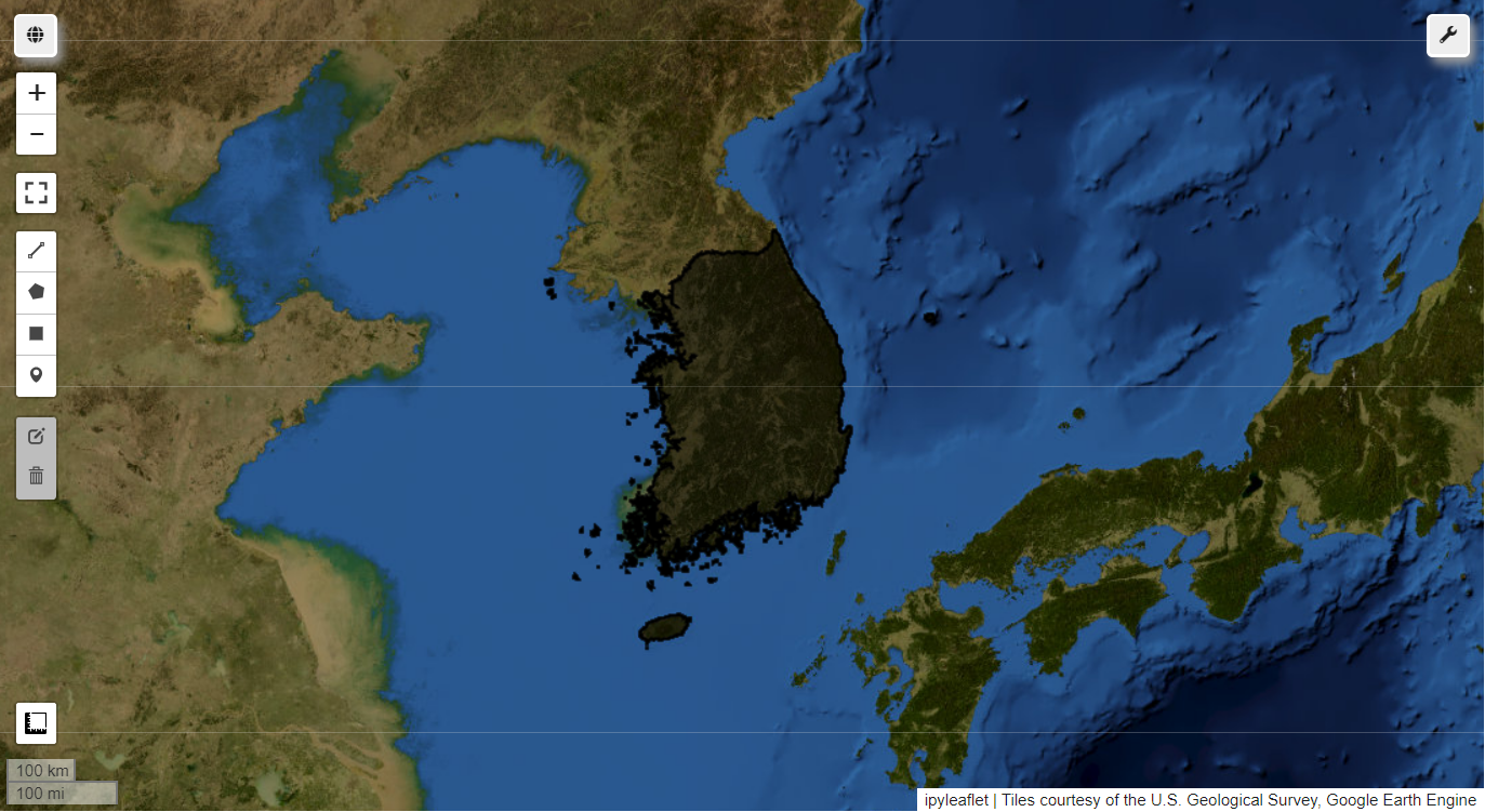
OpenLandMap Precipitation Monthly 데이터셋은 1월부터 12월까지 강수량을 제공합니다. 5월부터 9월까지 강수량 정보의 평균값을 MedianOLMP라는 변수로 정의하고 시각화해 보겠습니다.
# OpenLandMap Precipitation Monthly
Precip = ee.Image('OpenLandMap/CLM/CLM_PRECIPITATION_SM2RAIN_M/v01')
MeanPrecip = Precip.select("may", "jun", "jul", "aug", "sep").reduce(ee.Reducer.mean())
visParams = {
    'min': 0.0,
    'max': 380.0,
    'palette': ['ecffbd', 'ffff00', '3af6ff', '467aff', '313eff', '0008ff']}

# 지도 생성
Map = geemap.Map()

Map.centerObject(kr, 6) # 경계 중심으로 지도 확대
Map.addLayer(MeanPrecip, visParams, 'MedianOLMP')
Map.add_colorbar(visParams, label="Precipitation from May to Sep (mm)", orientation="vertical", layer_name="MedianOLMP")
Map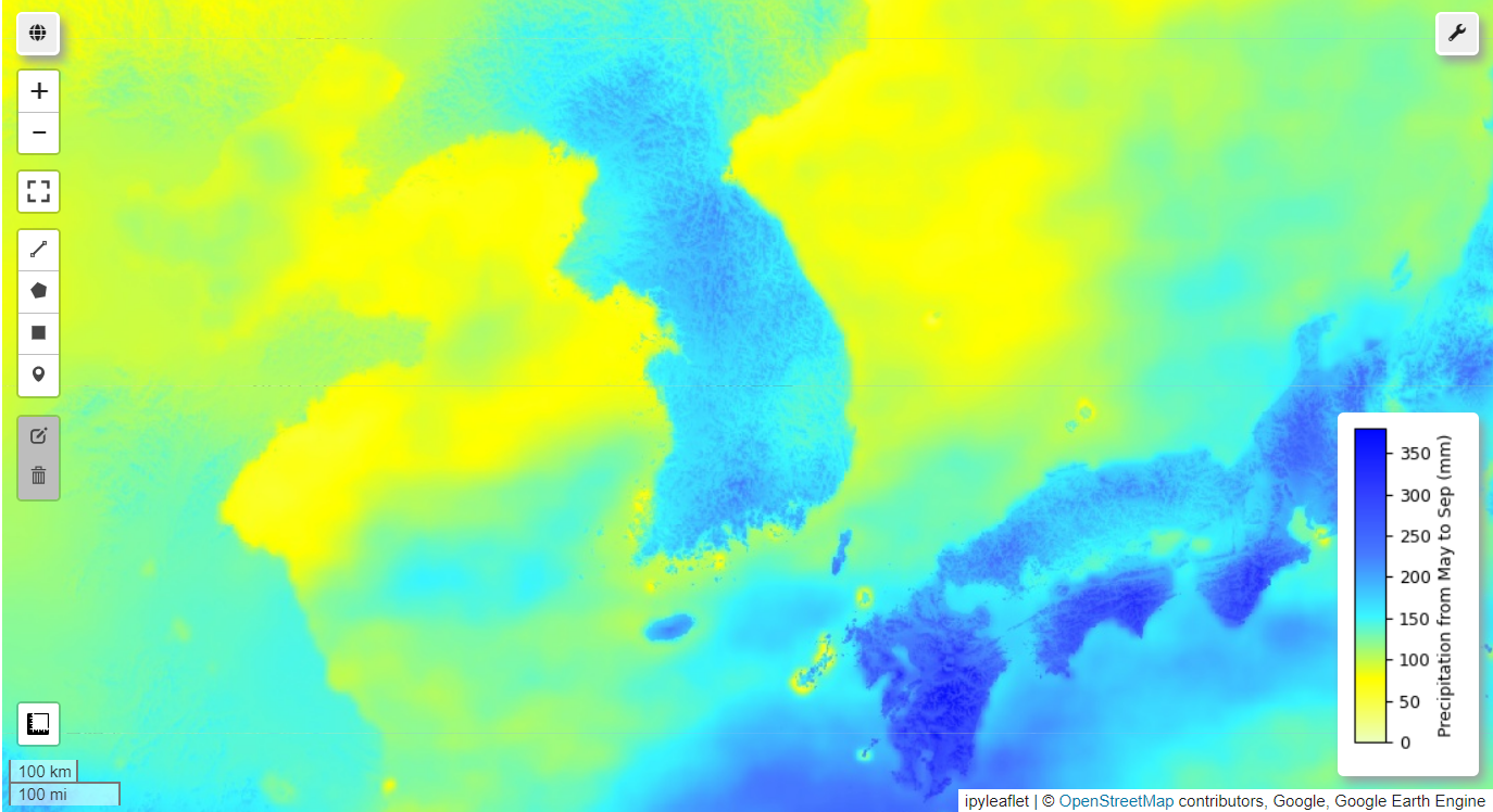
참고로, 해당 이미지는 아래 코드로 구글 드라이브에 저장 가능합니다. *손은희 님이 문의해주셔서 코드 추가했습니다. 감사합니다.
# 이미지를 Google Drive에 내보내기
geemap.ee_export_image_to_drive(MeanPrecip,
                                description='mean_precip',
                                folder='export',
                                region=kr.geometry(),
                                scale=1000,
                                maxPixels=1e13)